Mining Survey
Optimize stockpile measurements and pit modeling processes with a safer, faster, and more accurate data collection alternative compared to traditional surveying methods.
Painpoints
Advantages
Mining survey environments are often remote and fraught with safety risks that threaten personnel safety.
Swiftly cover vast and hazardous areas, significantly streamlining data collection process and enhancing personnel safety.
Traditional ground-based survey methods are costly, timely, and inefficient.
Reduce cost and improve efficiency with easy-to-deploy aerial data collection solutions.
Ensuring data quality through traditional methods can be challenging.
Repeat data collection missions ensuring the data quality and accuracy.
Solution
Portable Stockpike Measurement Solution
Full-Frame High Performance Surveying and Mapping Solution
Portable Stockpike Measurement Solution
The DJI Matrice 4E is a portable surveying and mapping drone suitable for single-pilot operations. Paired with DJI Terra, it can generate accurate 2D and 3D models with significant reduction on the ground control points.
Portable solution, easy to operate and to carry across multiple mine sites.
Reliability and high accuracy even when flying at high altitudes.
The Real-Time Terrain Following mode allows the Matrice 4E to adjust its altitude in real time, ensuring a consistent height relative to the terrain being mapped.
Drone Platform
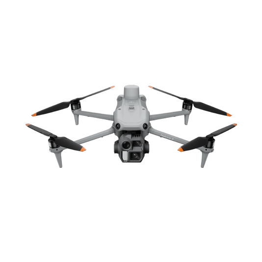
DJI Matrice 4E
... Open
Weight: 1219 g (with propellers)
Max Flight Time (without wind): 49 minutes
Environment Adaptability: Max takeoff altitude 6000 m, max wind speed resistance 12 m/s
Sensing System: Omnidirectional binocular vision system, supplemented with a 3D infrared sensor at the bottom of the aircraft
Mechanical Shutter Speed: 2-1/2000 s, minimum photo interval 0.5 s
Wide-Angle Camera: 4/3-inch CMOS, 20MP effective pixels
Medium Tele Camera: 1/1.3-inch CMOS, 48MP effective pixels
Telephoto Camera: 1/1.5-inch CMOS, 48MP effective pixels
Laser Rangefinding: 1800m measurement range (1 Hz) @20% reflectivity target
Workflow
- Data Collection:
- Plan a 2D map mission for regular orthomosaic data acquisition or a waypoint mission for regular site video recording and pano stitching. - Data Processing:
- Import the data to DJI Terra to process for DOM, DSM, Point Cloud, and 3D model outputs. - Data analysis:
- Perform anotations, measurements and volume analysis directly in DJI Terra. Import resulting DOM, DSM or 3D models into your preferred 3rd Party software for further analysis.
Full-Frame High Performance Surveying and Mapping Solution
Matrice 400 paired with the Zenmuse P1 full-frame sensor and it's Smart Oblique Capture feature takes aerial surveying efficiency and accuracy to a whole new level. Combine with DJI Terra for an efficient and integrated UAS surveying and mapping solution.
Reliable multi-purposed drone platform.
Zenmuse P1 has a 45MP, full-frame sensor to ensure high quality data collection.
Field-work efficiency—covers 3 km² per flight, delivering a 5cm GSD.
Generate accurate centimeter-level deliverables significantly reducing Ground Control Points.
Drone Platform
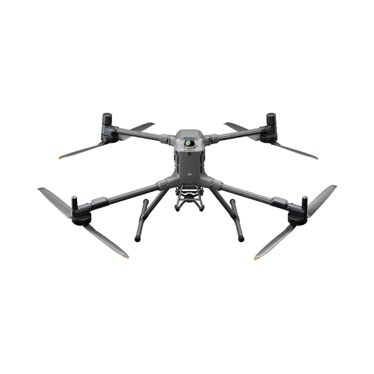
DJI Matrice 400
... Open
Weight: 9740±40 g (with batteries)
Max Takeoff Weight: 15.8 kg
Max Payload: 6 kg
Max Flight Time: 59 minutes
Max Horizontal Speed: 25 m/s
Sensing System: Omnidirectional binocular vision system (surround view provided by full-color fisheye vision sensors), horizontal rotating LiDAR, upper LiDAR, downward 3D infrared range sensor, and six-direction mmWave radar
Environment Adaptability: IP55 rating, max takeoff altitude 7000 m, operating temperature -20° to 50° C (-4° to 122° F)
Compatible with the Zenmuse H30 Series, Zenmuse L2, Zenmuse P1, Zenmuse V1, Zenmuse S1, and third-party payloads.
Payload And Software
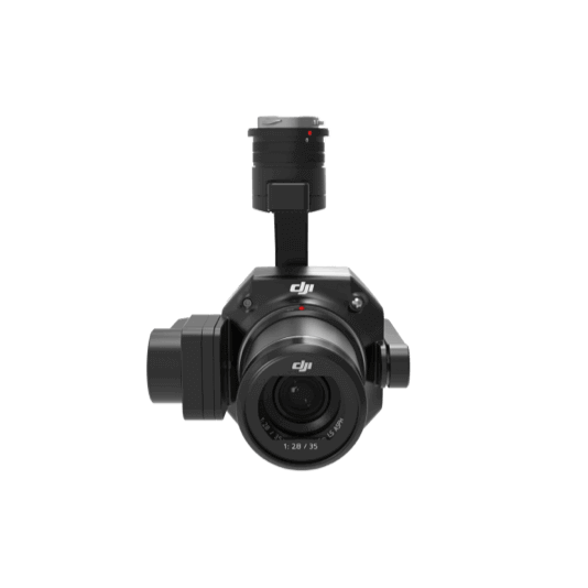
Zenmuse P1
... Open
45 MP Full-frame camera.
Global Mechanical Shutter Shutter Speed 1/2000 Seconds.
3-axis Stabilized Gimbal Smart Oblique Capture.
Global Mechanical Shutter Shutter Speed 1/2000 Seconds.
3-axis Stabilized Gimbal Smart Oblique Capture.

DJI Pilot 2
... Open
Ground control

Workflow
- Data Collection:
- Plan a 2D map mission for regular orthomosaic data acquisition or a waypoint mission for regular site video recording and pano stitching. - Data Processing:
- Import the data to DJI Terra to process for DOM, DSM, Point Cloud, and 3D model outputs. - Data analysis:
- Perform anotations, measurements and volume analysis directly in DJI Terra. Import resulting DOM, DSM or 3D models into your preferred 3rd Party software for further analysis.