Asset Inspection
Improve asset inspection efficiency with visual and thermal data collection without disrupting ongoing operations.
Painpoints
Advantages
Manual inspections are time-consuming and inefficient, especially across large mining sites.
Easily evaluate assets status, significantly streamlining data collection process.
Conventional inspection methods typically require significant manpower and resources.
Reduce cost and improve efficiency with easy-to-deploy aerial data collection solutions.
Low inspection frequency might lead to increased operational cost and equipment failures.
Collect real-time data, enabling mining operations to respond quickly to changing situations.
Mining assets in hard-to-reach locations present challenges for traditional inspection methods.
Aerial perspective allows you to view assets located difficult areas, offering a more comprehensive inspection.
Solution
Automated Remote Asset Inspection Solution
Robust Visual & Thermal Inspection Solution
Automated Remote Asset Inspection Solution
Deploy DJI Dock 3 at the mining site, and use the DJI FlightHub 2 as the control platform to remotely conduct on-site inspections and surveys. The mission progress is broadcasted live and the data can be synchronized to the cloud in real time.
Fully automated drone missions ensure consistent and regular data collection without the need for constant human oversight.
Minimizing the labor and time traditionally required for manual drone operations results in substantial cost savings.
Equipped with a high-accuracy mapping camera.
Easy to deploy and maintain,and can be operated normally even in high temperature, severe cold, high altitude and heavy rain environments.
Drone Platform
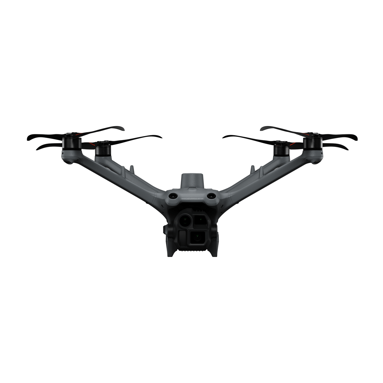
DJI Matrice 4D
... Open
Weight: 1850 g
Max Flight Time: 54 minutes
Environment Adaptability: IP55 rating, max takeoff altitude 6500 m, max wind speed resistance 12 m/s
Sensing System: Omnidirectional binocular vision system, supplemented with a 3D infrared sensor at the bottom of the aircraft
Mechanical Shutter Speed: 2-1/2000 s, minimum photo interval 0.5 s
Wide-Angle Camera: 4/3-inch CMOS, 20MP effective pixels
Medium Tele Camera: 1/1.3-inch CMOS, 48MP effective pixels
Telephoto Camera: 1/1.5-inch CMOS, 48MP effective pixels
Laser Rangefinding: 1800m measurement range (1 Hz) @20% reflectivity target
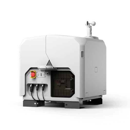
DJI Dock 3
... Open
Weight: 55 kg (without the drone)
Size: 1760×745×485 mm (L×W×H, dock cover opened)
Environment Adaptability: -30° to 50° C (-22° to 122° F) operating temperature, IP56 rating, maximum operating altitude 4500 m
Max Operating Radius: 10 km
Charging Time: 27 minutes
Security Camera (Internal) Resolution: 1920×1080
Size: 1760×745×485 mm (L×W×H, dock cover opened)
Environment Adaptability: -30° to 50° C (-22° to 122° F) operating temperature, IP56 rating, maximum operating altitude 4500 m
Max Operating Radius: 10 km
Charging Time: 27 minutes
Security Camera (Internal) Resolution: 1920×1080
Payload And Software

Workflow
- Data Collection:
- Plan a rountine mission for specific asset inspection or to navigate operation area. - Data Processing:
- Automate DJI FlightHub 2 data processing for 3D models. - Data analysis:
- Utilize DJI Terra or third-party software for further intelligent analysis.
Robust Visual & Thermal Inspection Solution
Matrice 400 paired with the Zenmuse H30T multi-sensor payload for visual and themal data collection, enables operators to inspect critical assets from a safe distance. The multi-purpose platform allows for payload exchange to perform different data collection flights depending on the operational needs.
Reliable & Robust multi-purposed drone platform.
H30T Payload features dual-visual, thermal and laser rangefinder sensors.
Field-work efficiency up to 59 minutes flight time.
Livestream inspection missions or upload collected data into DJI FlightHub 2 for convenient cross team collaboration.
Drone Platform
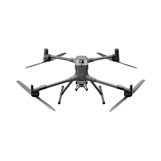
DJI Matrice 400
... Open
Weight: 9740±40 g (with batteries)
Max Takeoff Weight: 15.8 kg
Max Payload: 6 kg
Max Flight Time: 59 minutes
Max Horizontal Speed: 25 m/s
Sensing System: Omnidirectional binocular vision system (surround view provided by full-color fisheye vision sensors), horizontal rotating LiDAR, upper LiDAR, downward 3D infrared range sensor, and six-direction mmWave radar
Environment Adaptability: IP55 rating, max takeoff altitude 7000 m, operating temperature -20° to 50° C (-4° to 122° F)
Compatible with the Zenmuse H30 Series, Zenmuse L2, Zenmuse P1, Zenmuse V1, Zenmuse S1, and third-party payloads.
Payload And Software
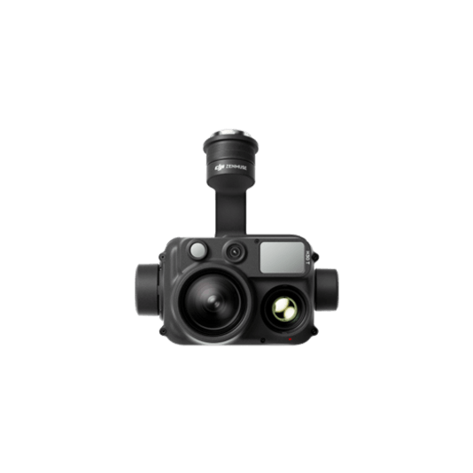
Zenmuse H30T
... Open
Wide-Angle RGB Camera: 1/1.3-inch CMOS, 48MP effective pixels
Zoom RGB Camera: 1/1.8-inch CMOS, 40MP effective pixels, 34× hybrid optical zoom
Infrared Thermal Camera: 1280×1024@30fps
NIR Auxiliary Light Illumination Range: Approx. 8m diameter circle@100 m
Laser Range Finder: Max measurement range 3000 m
Zoom RGB Camera: 1/1.8-inch CMOS, 40MP effective pixels, 34× hybrid optical zoom
Infrared Thermal Camera: 1280×1024@30fps
NIR Auxiliary Light Illumination Range: Approx. 8m diameter circle@100 m
Laser Range Finder: Max measurement range 3000 m
Workflow
- Data Collection:
- Manual inspection flight or use live mission recording for future repeteable mission. - Data Processing:
- Use DJI FlightHub 2 to provide live transimission feed or upload data collected in the cloud for efficient team collaboration. - Data analysis:
- Use DJI Thermal Analysis Tool or any preferred 3rd party software for in-depth thermal or visual analysis.