Forestry
Forest inventory and management involve conducting surveys over extensive areas. Drones enhance the data collection process by providing highly accurate and digitized data, leading to increased efficiency in forest management.
Painpoints
Advantages
Forest resource surveys are labor-intensive, and traditional methods demand significant manpower. This is particularly challenging in areas with complex geographical features where staff cannot easily access the site for surveys.
Drones are swift and adaptable, capable of quickly reaching and scanning areas of interest without being hindered by terrain or other conditions.
Conventional survey methods struggle to rapidly, comprehensively, and accurately capture information about the target and its surrounding environment.
They generate precise digital models of forests, facilitating effective management of forest inventories.
Solution
Accurate Forest Inventory
Matrice 400, outfitted with the Zenmuse L3 LiDAR, creates highly detailed 3D point cloud models of forests, enabling precise inventory management. Zenmuse L3's smaller spot size allows it to penetrate the forest canopy, revealing more information about the terrain and the forest's structure. Utilize DJI Terra to produce both photogrammetry and point cloud models, and classify the point cloud data for advanced forest analysis.
Create detailed 3D forest models by combining photogrammetry and LiDAR scanning with a single drone.
Survey extensive areas of up to 4 km² per flight (at 120 m).
Supports Linear, Star-Shaped, and Non-Repetitive scanning modes.
A range of outputs including Digital Elevation Models (DEM) and Digital Surface Models (DSM).
Advanced point cloud classification for in-depth forest analysis.
Drone Platform
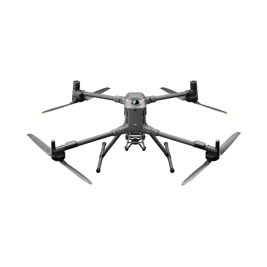
DJI Matrice 400
... Open
Weight: 9740±40 g (with batteries)
Max Takeoff Weight: 15.8 kg
Max Payload: 6 kg
Max Flight Time: 59 minutes
Max Horizontal Speed: 25 m/s
Sensing System: Omnidirectional binocular vision system (surround view provided by full-color fisheye vision sensors), horizontal rotating LiDAR, upper LiDAR, downward 3D infrared range sensor, and six-direction mmWave radar
Environment Adaptability: IP55 rating, max takeoff altitude 7000 m, operating temperature -20° to 50° C (-4° to 122° F)
Compatible with the Zenmuse H30 Series, Zenmuse L2, Zenmuse P1, Zenmuse V1, Zenmuse S1, and third-party payloads.
Payload And Software
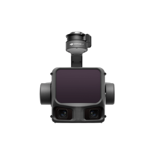
Zenmuse L3
... Open
Maximum Detection Range: 950 m (center), 650 m (edge)@10% reflectivity
Dual 4/3 CMOS RGB Mapping Cameras: Support 100MP or 25MP resolution
Vertical Accuracy: 3 cm, Horizontal Accuracy: 4 cm (at 120 m)
Vertical Accuracy: 5 cm, Horizontal Accuracy: 7.5 cm (at 300 m)
Single-flight coverage area up to 10 km² at an operational altitude of 300 m (nadir)
Dual 4/3 CMOS RGB Mapping Cameras: Support 100MP or 25MP resolution
Vertical Accuracy: 3 cm, Horizontal Accuracy: 4 cm (at 120 m)
Vertical Accuracy: 5 cm, Horizontal Accuracy: 7.5 cm (at 300 m)
Single-flight coverage area up to 10 km² at an operational altitude of 300 m (nadir)

DJI Pilot 2
... Open
Ground control

Workflow
- Data Collection:
- Using the DJI Pilot 2 app and the 3D Mapping Flight Mission feature, captured the data to generate a 3D model of the forest. - Data Processing:
- Input the data to DJI Terra, then reconstuct a high resolution 3D model. - Data Analysis:
- Perform point cloud classification to analyze forest status and make accurate decisions. Import the resulting point cloud into a third-party software for further forest management and analysis.