Precision Agriculture
Streamline data sampling with timely drone-based collection methods; optimizing crop management and effective disease control.
Painpoints
Advantages
It's difficult to accurately locate the crop areas that need attention without geotaged data.
Evaluate health and prevent diseases of each invidual crop with georeference data collection.
Manual samplings are lengthy and labor consuming, thus reducing the possible sampling frequency.
Increase data sampling frequency with fast aerial data collection.
Traditional crop evaluation methods rely on observation with limited data analysis.
Access a variety of data including RGB images, multispectral, thermal, and LiDAR data.
Limited visibility of the crop field overall health.
Cover larger areas in a single flight.
Solution
Portable Drone for Mapping and Stand Count Analysis Solution
Portable Multispectral Data Collection Solution
Precise Visual Vegetation Analysis Solution
Crop Biomass and Lanscape Analysis Solution
Large Farm Coverage & Routine Sampling Solution
Portable Drone for Mapping and Stand Count Analysis Solution
The DJI Matrice 4E is a portable surveying and mapping drone suitable for single-pilot operations. Pair with 3rd party stand count algorithms, the solution enables precise and quick estimations of stand count status, empowering informed decision-making in agriculture.
Portable solution, easy to operate and to carry across multiple farms and fields.
Centimiter level data thanks to its mechanical shutter and RTK capability.
Drone Platform
DJI Matrice 4E
... Open
Weight: 1219 g (with propellers)
Max Flight Time (without wind): 49 minutes
Environment Adaptability: Max takeoff altitude 6000 m, max wind speed resistance 12 m/s
Sensing System: Omnidirectional binocular vision system, supplemented with a 3D infrared sensor at the bottom of the aircraft
Mechanical Shutter Speed: 2-1/2000 s, minimum photo interval 0.5 s
Wide-Angle Camera: 4/3-inch CMOS, 20MP effective pixels
Medium Tele Camera: 1/1.3-inch CMOS, 48MP effective pixels
Telephoto Camera: 1/1.5-inch CMOS, 48MP effective pixels
Laser Rangefinding: 1800m measurement range (1 Hz) @20% reflectivity target
Workflow
- Data Collection:
- Plan a 2D map mission for regular orthomosaic data acquistion or waypoint mission for site video recording and pano stiching. - Data Processing:
- Import to collected images into DJI Terra to create 2D maps and 3D Models. - Data Analysis:
- Seamlessly integrate the results into third-party software for advanced stand count analysis, enhancing efficiency and accuracy in agricultural assessments.
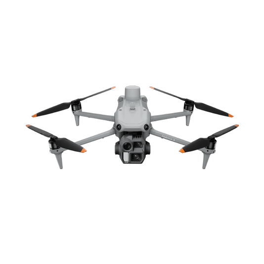
Portable Multispectral Data Collection Solution
The Mavic 3M offers effortless portability and swift deployments capable of collecting visual and multispectral data in a single flight. Paired with DJI Terra, process the vegetation indexes to gain insights into vegetation health and prescription maps for precise vegetation spraying.
Portable solution, easy to operate and to carry across multiple farms and fields.
Centimiter level data thanks to its mechanical shutter and RTK capability.
Vegetation health assessment with multispectral sensors.
Prescription map generation with DJI Terra.
Drone Platform

DJI Mavic 3M
... Open
Net Weight (with propellers and RTK module):951g.
Max Flight Time (without wind): 43 mins.
RGB Camera: 4/3 CMOS, effective pixels 20 MP.
Multispectral Camera: 1/2.8-inch CMOS, effective pixels: 5 MP
Multispectral Camera Band: Green (G): 560 ± 16 nm;
Red (R): 650 ± 16 nm;
Red Edge (RE): 730 ± 16 nm;
Near infrared (NIR): 860 ± 26 nm.
Environment Adaptability:
Max Take-off Altitude Above Sea Level 6000 m;
Max Wind Speed Resistance 12 m/s.
Workflow
- Data Collection:
- Plan a 2D mission and activate the multispectral sensor to acquire an aerial map enriched with multispectral bands data, providing a comprehensive view for precise analysis. - Data Processing:
- Import to DJI Terra to process the captured images, and generate 2D models if needed. - Data Analysis:
- Analyze the collected vegetation indexes for in-depth analysis of crop health. Generate prescription maps for accurate crop spraying.
Precise Visual Vegetation Analysis Solution
Our drone solution excels in agricultural monitoring by capturing high-resolution images for Intelligent Model- Driven disease detection, efficiently covering large farmlands. The Matrice 400 versatility extends to working with third-party payloads, facilitating the collection of multispectral and hyperspectral data for precise analysis.
Field-work efficiency, covers 3 km² per flight delivering a 5cm GSD.
Reliable multi-purposed drone platform designed to endure harsh environments and conditions.
Zenmuse P1 has a 45MP, full-frame sensor to ensure high quality data collection.
Suitable for Intelligent Model- Driven disease detection through high resolution imagery.
Drone Platform
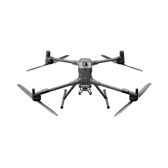
DJI Matrice 400
... Open
Weight: 9740±40 g (with batteries)
Max Takeoff Weight: 15.8 kg
Max Payload: 6 kg
Max Flight Time: 59 minutes
Max Horizontal Speed: 25 m/s
Sensing System: Omnidirectional binocular vision system (surround view provided by full-color fisheye vision sensors), horizontal rotating LiDAR, upper LiDAR, downward 3D infrared range sensor, and six-direction mmWave radar
Environment Adaptability: IP55 rating, max takeoff altitude 7000 m, operating temperature -20° to 50° C (-4° to 122° F)
Compatible with the Zenmuse H30 Series, Zenmuse L2, Zenmuse P1, Zenmuse V1, Zenmuse S1, and third-party payloads.
Payload And Software
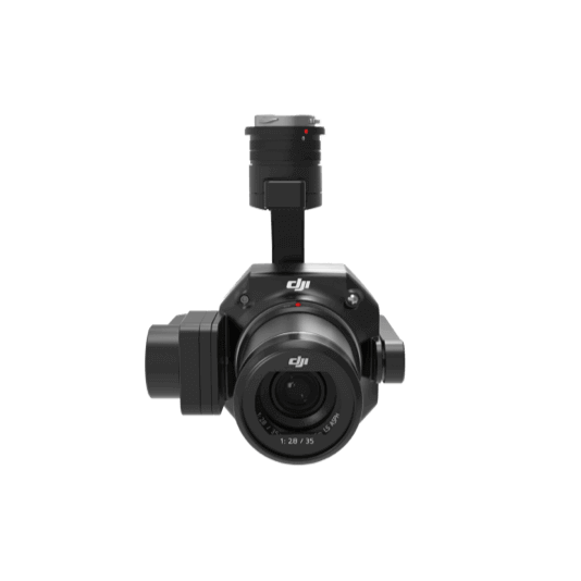
Zenmuse P1
... Open
45 MP Full-frame camera.
Global Mechanical Shutter Shutter Speed 1/2000 Seconds.
3-axis Stabilized Gimbal Smart Oblique Capture.
Global Mechanical Shutter Shutter Speed 1/2000 Seconds.
3-axis Stabilized Gimbal Smart Oblique Capture.

DJI Pilot 2
... Open
Ground control

Workflow
- Data Collection:
- Plan a 2D mission with precise Ground Sample Distance (GSD) for capturing detailed images of leaf area and crop structures. - Data Processing:
- Import to DJI Terra to process the captured images, and generate 2D models if needed. - Data Analysis:
- Utilize the captured high-resolution images to train specialized models for efficient disease detection, enhancing precision in agricultural monitoring.
Crop Biomass and Lanscape Analysis Solution
Matrice 400 equipped with the Zenmuse L3 LiDAR sensor is an ideal solution for precise volume and land structure estimation, offering insights into crop biomass and business potential. Additionally, it seamlessly combines with an RGB sensor for efficient stand count information. Matrice 400's versatility extends to working with third-party payloads, facilitating the collection of multispectral and hyperspectral data for precise analysis.
Field-Work Efficiency: Covers 4 km² per flight (at 120 m), collecting both LiDAR and photogrammetry data.
Highly Integrated Solution: Reduces on-site time and ensures data capture quality.
Reliable and Robust Multi-Purpose Drone Platform: Endures harsh environments and conditions.
Drone Platform
DJI Matrice 400
... Open
Weight: 9740±40 g (with batteries)
Max Takeoff Weight: 15.8 kg
Max Payload: 6 kg
Max Flight Time: 59 minutes
Max Horizontal Speed: 25 m/s
Sensing System: Omnidirectional binocular vision system (surround view provided by full-color fisheye vision sensors), horizontal rotating LiDAR, upper LiDAR, downward 3D infrared range sensor, and six-direction mmWave radar
Environment Adaptability: IP55 rating, max takeoff altitude 7000 m, operating temperature -20° to 50° C (-4° to 122° F)
Compatible with the Zenmuse H30 Series, Zenmuse L2, Zenmuse P1, Zenmuse V1, Zenmuse S1, and third-party payloads.
Max Takeoff Weight: 15.8 kg
Max Payload: 6 kg
Max Flight Time: 59 minutes
Max Horizontal Speed: 25 m/s
Sensing System: Omnidirectional binocular vision system (surround view provided by full-color fisheye vision sensors), horizontal rotating LiDAR, upper LiDAR, downward 3D infrared range sensor, and six-direction mmWave radar
Environment Adaptability: IP55 rating, max takeoff altitude 7000 m, operating temperature -20° to 50° C (-4° to 122° F)
Compatible with the Zenmuse H30 Series, Zenmuse L2, Zenmuse P1, Zenmuse V1, Zenmuse S1, and third-party payloads.
Payload And Software
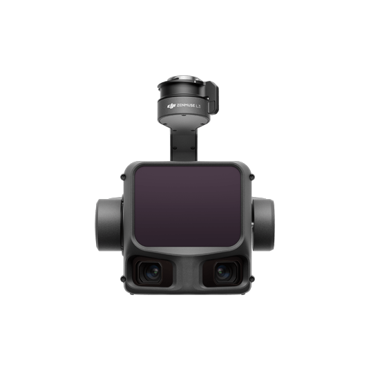
Zenmuse L3
... Open
Maximum Detection Range: 950 m (center), 650 m (edge)@10% reflectivity
Dual 4/3 CMOS RGB Mapping Cameras: Support 100MP or 25MP resolution
Vertical Accuracy: 3 cm, Horizontal Accuracy: 4 cm (at 120 m)
Vertical Accuracy: 5 cm, Horizontal Accuracy: 7.5 cm (at 300 m)
Single-flight coverage area up to 10 km² at an operational altitude of 300 m (nadir)
Dual 4/3 CMOS RGB Mapping Cameras: Support 100MP or 25MP resolution
Vertical Accuracy: 3 cm, Horizontal Accuracy: 4 cm (at 120 m)
Vertical Accuracy: 5 cm, Horizontal Accuracy: 7.5 cm (at 300 m)
Single-flight coverage area up to 10 km² at an operational altitude of 300 m (nadir)
DJI Pilot 2
... Open
Ground control
Workflow
- Data Collection:
- Plan a 2D mission to collect both Point Cloud and true color images, providing comprehensive data for accurate analysis of crop characteristics. - Data Processing:
- Import to DJI Terra to process for DOM, DSM, Point Cloud, orthomosaic images and 3D models. - Data Analysis:
- Import the acquired models into your preferred 3rd party software for further crop classification, volume estimation, and biomass classification.
Large Farm Coverage & Routine Sampling Solution
Our solution, powered by the DJI Dock 3, enables high-frequency crop data collection for comprehensive insights into seasonal growth trends and health management. By eliminating the need for manual visits, it significantly saves manpower and minimizes costs, optimizing resource allocation for enhanced operational efficiency in agriculture.
Schedule routine data collection flights over the construction site to efficently track project progress.
Upload the collected data into DJI FlightHub 2 or preferred 3rd party software for in-depth crop analysis.
Drone Platform
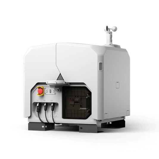
DJI Dock 3
... Open
Weight: 55 kg (without the drone)
Size: 1760×745×485 mm (L×W×H, dock cover opened)
Environment Adaptability: -30° to 50° C (-22° to 122° F) operating temperature, IP56 rating, maximum operating altitude 4500 m
Max Operating Radius: 10 km
Charging Time: 27 minutes
Security Camera (Internal) Resolution: 1920×1080
Size: 1760×745×485 mm (L×W×H, dock cover opened)
Environment Adaptability: -30° to 50° C (-22° to 122° F) operating temperature, IP56 rating, maximum operating altitude 4500 m
Max Operating Radius: 10 km
Charging Time: 27 minutes
Security Camera (Internal) Resolution: 1920×1080
Payload And Software

Workflow
- Data Collection:
- Plan a routine 2D map mission for regular orthomosaic data acquisition. - Data Processing:
- Import collected data into your preferred 3rd Party Software for in-depth crop analysis. - Data Analysis:
- Use the captured images to train specialized models for efficient disease detection.