Urban Planning
Create accurate 2D and 3D models that integrate seamlessly with local geographic information systems, helping teams visualize results.
Painpoints
Advantages
Land Management and Land Use Planning relies on a combination of low resolution images, physical maps, and contour maps, which are low-resolution and not frequently updated.
Keep data accurate and up to date with drone-generated 2D maps and 3D models for more informed design and planning.
Urban data collection is inefficient and time-consuming due to complex environments.
Increase mapping efficiency in cities or rural areas with easy-to-create flight plans, reducing costs and field work duration.
Solution
Portable Drone Surveying & Mapping Solution
Full-Frame High-Performance Surveying and Mapping Solution
Portable Drone Surveying & Mapping Solution
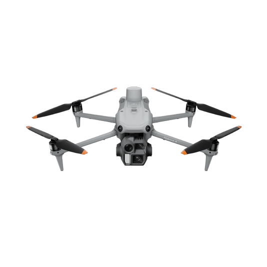
The DJI Matrice 4E is a portable surveying and mapping drone suitable for single-pilot operations. Paired with DJI Terra, it can generate accurate 2D and 3D models with significant reduction on the ground control points.
Portable solution, easy to carry and deploy.
Centimeter-level data thanks to its mechanical shutter and RTK capability.
Ensure operational safety with omnidirectional obstacle avoidance sensors.
Field-work efficiency, covers 2 km² per flight delivering a 5cm GSD.
Real-Time Terrain Follow feature to ensure high-quality data capture in challenging and variable terrains.
Drone Platform
DJI Matrice 4E
... Open
Weight: 1219 g (with propellers)
Max Flight Time (without wind): 49 minutes
Environment Adaptability: Max takeoff altitude 6000 m, max wind speed resistance 12 m/s
Sensing System: Omnidirectional binocular vision system, supplemented with a 3D infrared sensor at the bottom of the aircraft
Mechanical Shutter Speed: 2-1/2000 s, minimum photo interval 0.5 s
Wide-Angle Camera: 4/3-inch CMOS, 20MP effective pixels
Medium Tele Camera: 1/1.3-inch CMOS, 48MP effective pixels
Telephoto Camera: 1/1.5-inch CMOS, 48MP effective pixels
Laser Rangefinding: 1800m measurement range (1 Hz) @20% reflectivity target
Workflow
- Data Collection:
- Plan a 2D, Linear Flight or Smart Oblique Mission based on the actual landscape situation for regular orthomosaic images, or oblique images data collection. Enable Real-Time Terrain Follow feature. - Data Processing:
- Import to DJI Terra to process for DOM, DSM, Point Cloud and 3D models. - Data Analysis:
- Import DJI Terra outputs to preferred third party software for further analysis.
Full-Frame High-Performance Surveying and Mapping Solution
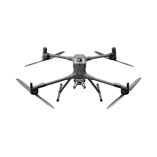
Matrice 400 paired with the Zenmuse P1 full-frame sensor and its Smart Oblique Capture feature takes aerial surveying efficiency and accuracy to a whole new level. Combine with DJI Terra for an efficient and integrated UAS surveying and mapping solution.
Generate accurate centimeter-level deliverables even without ground control points.
Field-work efficiency, covers 3 km² per flight delivering a 5cm GSD.
Reliable and robust multi-purposed drone platform designed to endure harsh environments and conditions.
Zenmuse P1 has a 45MP, full-frame sensor to ensure high quality data collection.
Drone Platform
DJI Matrice 400
... Open
Weight: 9740±40 g (with batteries)
Max Takeoff Weight: 15.8 kg
Max Payload: 6 kg
Max Flight Time: 59 minutes
Max Horizontal Speed: 25 m/s
Sensing System: Omnidirectional binocular vision system (surround view provided by full-color fisheye vision sensors), horizontal rotating LiDAR, upper LiDAR, downward 3D infrared range sensor, and six-direction mmWave radar
Environment Adaptability: IP55 rating, max takeoff altitude 7000 m, operating temperature -20° to 50° C (-4° to 122° F)
Compatible with the Zenmuse H30 Series, Zenmuse L2, Zenmuse P1, Zenmuse V1, Zenmuse S1, and third-party payloads.
Payload And Software
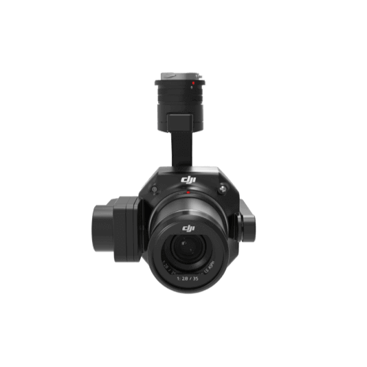
Zenmuse P1
... Open
45 MP Full-frame camera.
Global Mechanical Shutter Shutter Speed 1/2000 Seconds.
3-axis Stabilized Gimbal Smart Oblique Capture.
Global Mechanical Shutter Shutter Speed 1/2000 Seconds.
3-axis Stabilized Gimbal Smart Oblique Capture.

DJI Pilot 2
... Open
Ground control

Workflow
- Data Collection:
- Plan a 2D, Linear Flight or Smart Oblique Mission based on the actual landscape situation for regular orthomosaic images, or oblique images data collection. Import DSM files for Terrain Follow if necessary. - Data Processing:
- Import to DJI Terra to process for DOM, DSM, Point Cloud and 3D models. - Data Analysis:
- Import DJI Terra outputs to preferred third party software for further analysis.