On Nov. 8, 2018, a forest fire tore through the towns of Paradise and Magalia in northern California, destroying more than 18,000 structures and killing at least 85 people. The so-called “Camp Fire” would come to be known as “the deadliest and most destructive fire in California” in the media. Unfortunately, it was far from the first, or the last.
A growing number of similar, out-of-control wildfires in northern California have begun to reveal the benefits that drones and other unmanned aircraft systems (UAS) can provide for response and recovery operations. The Camp Fire response mission teams sent their drones on 518 different mapping flights through smoky conditions and collected 1.4 trillion pixels of data that were georeferenced and stitched into map formats. With up-to-date visuals, fire teams charted the damage and planned next steps. In some cases, homeowners were even able to submit the imagery from drone maps to insurance providers to process claims almost immediately — a process that traditionally can take days or weeks. Many have used the imagery to gain access to FEMA relief funds for the families affected by the fires.
Drones are particularly crucial for forest fires that tend to get out of control quickly and put both pilots and crew at risk. There’s only a small containment window between when the fire starts and when it gets out of control. Drones give firefighters a bird’s eye view of the terrain and help them determine where the fire moves next, so they can swiftly make decisions about where crews should go and who should be evacuated.
“It goes back to the old saying, 'A picture is worth a thousand words, right?" said David Danielson, one of the two lead pilots for the Los Angeles Fire Department (LAFD) UAS program. "You're creating that situational awareness, you're mitigating risk, you're preventing injury to the firefighters and you're preserving the property that you're trying to save.”
If you’re a firefighter responsible for forest fire response, mitigation, and rescue, the benefits of drones are immense. We’ve detailed four major benefits with supplemental stories below.

1. Gather situational awareness in a short time
A drone helps you decide within minutes the type and amount of resources to send to the scene of a forest fire. Some drones are also equipped with thermal sensors, which use infrared radiation to help first responders locate heat signatures of humans and fire hotspots that show where fires are most likely to spread.
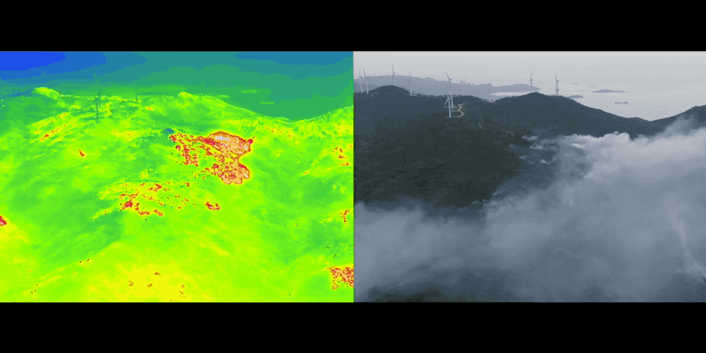
On Oct. 23, 2020, a forest fire broke out in Nan’ao county, a mountainous rural area in south China. High-speed winds moved the blaze around, leading to the formation of three fire sites. Public safety officials were required to mobilize all of their forces to contain the fire. To gather the most information possible and ensure resources were distributed appropriately, the frontline crew relied on a DJI Matrice 300 RTK drone equipped with an H20T hybrid sensor i.e., both visible light and radiometric infrared sensors. With these tools, the team was able to gain a new level of situational awareness. Once the majority of the fire had been extinguished, the team used their drone to find and eliminate smoke points that could have lead to reignition.
Drone data can also help ensure that decision-makers are all on the same page. A wildfire response often involves large-scale operations where the incident commander must make decisions on personnel and resource deployment. Drones are effective intelligence generators that can capture detailed data and information from the field, and live stream back to the command center. By having that real-time aerial view, you can see exactly what’s happening and don’t have to rely on secondhand information. You know what’s going on and where. You can also monitor your crew to see their location and that you’re sending them in the right direction.
2. Protect your personnel
With aerial intelligence captured by drones, incident commanders can make informed decisions that keep firefighters safe while they plunge into the fire and work to save peoples’ lives. With a drone, you can monitor your crew from afar to ensure they’re safe and heading in the right direction. In addition, drone footage can inform you where to send backup forces.
On Aug. 13, 2017, Yosemite-area firefighters battled a nine-day blaze in Southfork, California, that was complicated by weakened timber trees in the nearby region. Flying manned aircraft in the tight canyons was dangerous due to a billowing column of smoke. At the same time, an unexpected thunderstorm spread the fire, blurring the firefighters’ primary containment line and threatening to spread to nearby villages.
To protect the crew, the Yosemite fire force used a DJI drone with the Zenmuse XT thermal payload to map fire lines and live stream information to controllers for operational decisions and situational awareness. As Menlo Park Fire Department Captain Tony Eggiman recalled, “The operations major told me later it brought his blood pressure from about 200 down to about 100. He was really happy.”
And firefighters today can trust that thermal drone technology has only improved since 2017. With the M300 RTK and the H20T, response teams are benefitting from longer flight times up to 55 minutes, increased weather resistance, and higher quality data with zoom and pinpoint functionality.
3. Enable fast mapping for incident response as well as for post-incident recovery
All too often, inadequate infrastructure and challenging terrain make it dangerous, time-consuming, and ineffective to patrol high-risk areas for potential signs of a potential fire. With drone mapping, teams can get a full view of the situation of the ground quickly and gain the understanding they need.
To get the job done, drone solutions for forest fire response typically carry visual and thermal cameras. The former gives you a real-time view of different situations and is able to easily spot your fire team or nearby equipment. A visual camera can also be used to inform a team about difficult topography or other challenges that may lie between them and a fire. The thermal camera, meanwhile, scouts for heat signatures of the human crew or fire hotspots. This can help locate hotspots at a fire scene within seconds, and see people trapped even in areas of thick smoke. Thermal cameras provide essential information that simply can't be gleaned from a visual map.
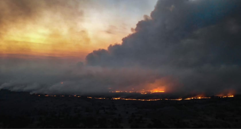
The benefits of firefighting drones were made clear in a massive wildfire that broke out on April 4th, 2020 near the Chernobyl exclusion zone. As blazes threatened over 40,000 hectares of volatile forests, black smoke made it nearly impossible for visual cameras to see the source and scope of the growing fires. Responders deployed 10 drones with thermal sensors and were able to quickly and efficiently locate hotspots. Rapid mapping of the fire helped incident commanders direct ground crews of 1,000 firefighters and 120 fire trucks to quickly and safely extinguish the fire.
Closer and cheaper than a helicopter
While visual and thermal mapping can be conducted with manned aircraft, drone mapping has the potential to offer a full picture. Drones can gather data from vantage points that planes and helicopters simply can’t and can fly at times that would be too dangerous for a manned aircraft. Drones fly lower than helicopters, providing a more nuanced picture of the situation, and can navigate in tight or dangerous spaces where no helicopter pilot would dare to go. In some cases, drones and firefighting helicopters can even be used in tandem to cover the most terrain possible.
During the 2017 North Umpqua Fire in Oregon, for example, the U.S. Department of the Interior (DOI) used a drone with an infrared camera to find smaller spot fires that a helicopter may have missed. The DOI estimated the discovery of the fire prevented about $50 million in property and infrastructure damage. It’s important to note, however, that unauthorized drones should not go anywhere near manned aircraft.
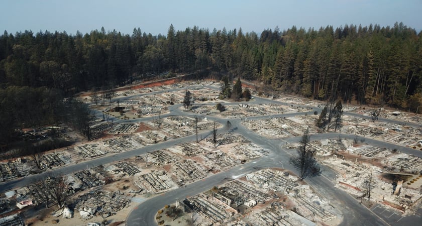
Drones also play an important role after the fire has been put out, making recovery from the destruction possible in a quicker timeline. During the Carr Fire, crews piloted low-flying drones to capture 360-degree images of the destruction. For the residents forced out of their homes, this provided invaluable information on property damage to assess insurance claims more quickly, letting victims take steps to rebuild their lives sooner rather than later.
4. Administer prescribed burns
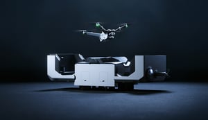
One of the key tools scientists and firefighters use to prevent wildfire is controlled, prescribed burning. This technique involves intentionally setting small fires under set conditions to clear buildups of brush and other parts of the ecosystem that could become fuel in a future, unplanned fire. While controlled burns are traditionally lit with handheld drip torches, solutions like IGNIS, a payload built specifically for firefighting, allow a drone pilot to remotely conduct controlled burning operations, keeping all personnel at a safe distance.
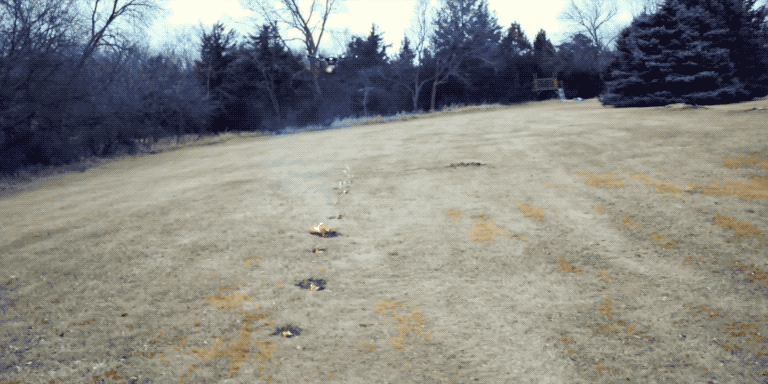
Working in conjunction with the DJI Matrice 600 Pro, IGNIS can drop ping pong ball-sized ignition spheres into the desired location. Each individual sphere is filled with potassium permanganate which, when combined with ethylene glycol before being dropped, starts a chemical reaction. The small size of the spheres allows a drone pilot to easily control the size and location of the burn.
Missions can be handled manually or be automated with the IGNIS app. This allows firefighters to upload existing topographic overlays for a flight path that matches the environment. For best results, use the Zenmuse H20T hybrid-thermal camera to watch how controlled fires are progressing in real-time and make adjustments on the fly.
Conclusion: The future of firefighting
Across the globe, destructive wildfires are becoming more and more commonplace. Of the top 20 largest wildfires in California state history, six of them occurred in 2020 alone. Australia, meanwhile, saw wildfires consume millions of acres of land and destroy billions of dollars of property. Luckily, armed with new technology, firefighters are bravely rising to the challenge. Crews are using drone innovation to respond rapidly, distribute resources, and ultimately save lives and property. Drones have also become imperative in the days and months before and after a fire — helping to facilitate preventive controlled burns and offering victims a way to quickly record the damage to their property for insurance purposes.
To understand more about how the right drone, paired with a thermal camera, can make a difference fighting fire in your community, download our white paper Fighting Fire With Thermal: DJI’s Complete Guide to Thermal Drones.