Roof Inspection
Drones can inspect roofs for cracks, leaks, and other types of damage, thereby ensuring the safety of employees by keeping them off hazardous rooftops.
Painpoints
Advantages
Traditional methods of roof inspection expose personnel to significant risks.
Enhance safety by eliminating the need for personnel to climb or be exposed to hazardous environments.
Manual assessments and documentation are required, making the process inefficient and prone to inaccuracies.
Drone data can be easily verified, stored, and monitored over time for consistency and accuracy.
Some roof defects are not easily detectable through visual inspection alone.
Aerial thermal imagery offers additional insights into the condition of the roof, revealing issues not visible to the naked eye.
Solution
Roof Mapping and Visual Inspection
Cost-Effective Thermal Roof Inspections
Roof Mapping and Visual Inspection
The DJI Matrice 4E is a precise and portable mapping drone. Utilizing the DJI Pilot 2 app to create a straightforward flight plan, inspection teams can swiftly capture comprehensive images of any roof within minutes. This drone delivers accuracy down to the centimeter and reveals details as fine as a millimeter.
The Matrice 4E offers a portable and user-friendly solution, streamlining the transportation and operation process during roof inspections.
Achieve centimeter-level precision with the drone's mechanical shutter and Real-Time Kinematic (RTK) technology.
Capture millimeter-level details effortlessly, even in dimly lit conditions, thanks to the drone's large 4/3-inch sensor.
Generate various data outputs, including detailed 2D maps of roofs and intricate 3D models of buildings.
Drone Platform
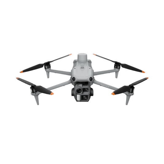
DJI Matrice 4E
... Open
Weight: 1219 g (with propellers)
Max Flight Time (without wind): 49 minutes
Environment Adaptability: Max takeoff altitude 6000 m, max wind speed resistance 12 m/s
Sensing System: Omnidirectional binocular vision system, supplemented with a 3D infrared sensor at the bottom of the aircraft
Mechanical Shutter Speed: 2-1/2000 s, minimum photo interval 0.5 s
Wide-Angle Camera: 4/3-inch CMOS, 20MP effective pixels
Medium Tele Camera: 1/1.3-inch CMOS, 48MP effective pixels
Telephoto Camera: 1/1.5-inch CMOS, 48MP effective pixels
Laser Rangefinding: 1800m measurement range (1 Hz) @20% reflectivity target

Workflow
- Data Collection:
- Perform a quick test flight to verify building height, then plan a 2D map mission about 50-100 (15-30 Meters) feet above the rooftop. - Data Processing:
- Import to DJI Terra to process a high quality 2D map of the roof and 3D model of the building. - Data Analysis:
- Highlight problem areas in Terra or third-party processing software, then export issues flagged to an internal ERP software for maintenance team to fix.
Cost-Effective Thermal Roof Inspections
The DJI Matrice 4T enables pilots to capture not only visual images for roof inspections but also thermal imagery that reveals issues invisible to the naked eye. By utilizing both types of imagery, inspection teams can enhance their capability to detect all roofing faults, thereby increasing the accuracy of their inspections.
A portable and user-friendly solution that simplifies transportation and operation during roof inspections.
Equipped with a high-quality thermal sensor to identify and document roofing imperfections.
Utilize the DJI Thermal Analysis Tools to analyze thermal data for a deeper understanding of each thermal anomaly.
Drone Platform
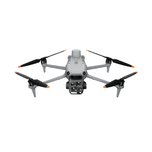
DJI Matrice 4T
... Open
Weight: 1219 g (with propellers)
Max Flight Time (without wind): 49 minutes
Environment Adaptability: Max takeoff altitude 6000 m, max wind speed resistance 12 m/s
Sensing System: Omnidirectional binocular vision system, supplemented with a 3D infrared sensor at the bottom of the aircraft
Wide-Angle Camera: 1/1.3-inch CMOS, 48MP effective pixels (Matrice 4T)
Medium Tele Camera: 1/1.3-inch CMOS, 48MP effective pixels
Telephoto Camera: 1/1.5-inch CMOS, 48MP effective pixels
Infrared Thermal Camera: 1280 × 1024@30fps (Super Resolution enabled, Night Mode not activated)
Laser Rangefinding: 1800m measurement range (1 Hz) @20% reflectivity target
Payload And Software

DJI Pilot 2
... Open
Ground control

DJI Thermal Analysis Tool 3
... Open
By identifying the temperature information of critical areas of the target, the software can be used to analyze objects across many industrial applications.
Workflow
- Data Collection:
- Perform a quick test flight to verify building height, then plan a 2D map mission about 50-75 (15 - 25 meters) feet above the rooftop. - Data Processing:
- Import the visual imagery to DJI Terra to process a high quality 2D map of the roof and 3D model of the building. - Data Analysis:
- Highlight problem areas in Terra or third-party processing software from the visual data. Also analyze individual thermal imagery in DJI Thermal Analysis Tools. Then export issues flagged to an internal ERP software for maintenance team to fix.