Collision Reconstruction and Forensics
Clear roads faster with efficient and accurate drone-based data collection and reconstruction. Ensure personnel safety and digitize your forensics process.
Painpoints
Advantages
There is an increased risk for forensic personnel when performing manual reconstruction.
Collect data from a safe distance without compromising data quality or exposing personnel to unnecessary risk.
Traffic is significantly impacted by the long reconstruction times and delays in road clearing.
Significantly reduce collection times, restoring normal traffic flow more quickly and minimizing the impact on transportation.
Inadequate data collection and a lack of realistic visual representation can add complexity to legal cases.
Capture realistic reconstruction models of the scene, which can be later used throughout the legal process.
Solution
Portable Scene Reconstruction
Large Scale Scene Reconstruction
Portable Scene Reconstruction
The Matrice 4E offers unparalleled portability for quick reconstruction missions. Easy to carry in patrol vehicles and equipped with a 20MP camera and RTK module, it's an ideal solution for fast but accurate scene reconstruction. Paired with DJI Terra and DJI Modify, it can create realistic 3D models to serve as evidence or for forensic analysis.
20MP 4/3 CMOS Sensor for high-quality reconstruccion models.
Compact and lightweight design, less than 1kg and easy to carry in a patrol vehicle.
Fast and easy deployment, get airborne in around 30 seconds.
Mechanical shutter with 0.5s interval to improve efficiency and reduce data collection times.
Automated mapping mission modes to optimize data collection.
Drone Platform
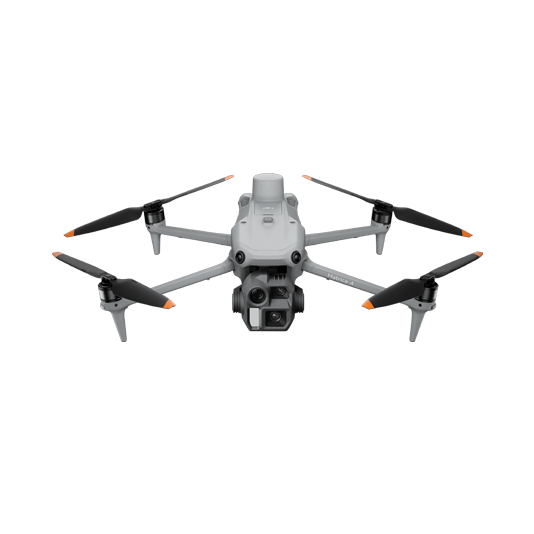
DJI Matrice 4E
... Open
Weight: 1219 g (with propellers)
Max Flight Time (without wind): 49 minutes
Environment Adaptability: Max takeoff altitude 6000 m, max wind speed resistance 12 m/s
Sensing System: Omnidirectional binocular vision system, supplemented with a 3D infrared sensor at the bottom of the aircraft
Mechanical Shutter Speed: 2-1/2000 s, minimum photo interval 0.5 s
Wide-Angle Camera: 4/3-inch CMOS, 20MP effective pixels
Medium Tele Camera: 1/1.3-inch CMOS, 48MP effective pixels
Telephoto Camera: 1/1.5-inch CMOS, 48MP effective pixels
Laser Rangefinding: 1800m measurement range (1 Hz) @20% reflectivity target
Workflow
- Mission Planning:
- Plan Mapping Mission based on scene reconstruction needed. - Mission Execution:
- Execute the planned mission. Complement the images with POI flights using timed photo capture.
- For night reconstructions, make sure to properly light the scene for accurate data collection. - Post Mission Documentation:
- Import collected data in DJI Terra to process the scene 3D model.
- Use DJI Modify to clean a version of the 3D model, remove any floating parts, and improve overall texture quality. Sharing with other stakeholders is also possible.
Large Scale Scene Reconstruction
The Matrice 400, equipped with the Zenmuse P1, allows law enforcement and forensic teams to map vast incident areas with great quality and accuracy. Process the collected data with DJI Terra and DJI Modify for optimal processing efficiency and modeling quality.
Reliable multipurpose drone platform for reconstruction missions in challenging conditions.
Zenmuse P1 has a 45MP, full-frame sensor to ensure high-quality data collection.
Generate accurate centimeter-level deliverables.
Field-work efficiency—covers 3 km² per flight, delivering a 5cm GSD.
Drone Platform
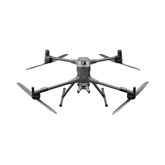
DJI Matrice 400
... Open
Weight: 9740±40 g (with batteries)
Max Takeoff Weight: 15.8 kg
Max Payload: 6 kg
Max Flight Time: 59 minutes
Max Horizontal Speed: 25 m/s
Sensing System: Omnidirectional binocular vision system (surround view provided by full-color fisheye vision sensors), horizontal rotating LiDAR, upper LiDAR, downward 3D infrared range sensor, and six-direction mmWave radar
Environment Adaptability: IP55 rating, max takeoff altitude 7000 m, operating temperature -20° to 50° C (-4° to 122° F)
Compatible with the Zenmuse H30 Series, Zenmuse L2, Zenmuse P1, Zenmuse V1, Zenmuse S1, and third-party payloads.
Payload And Software
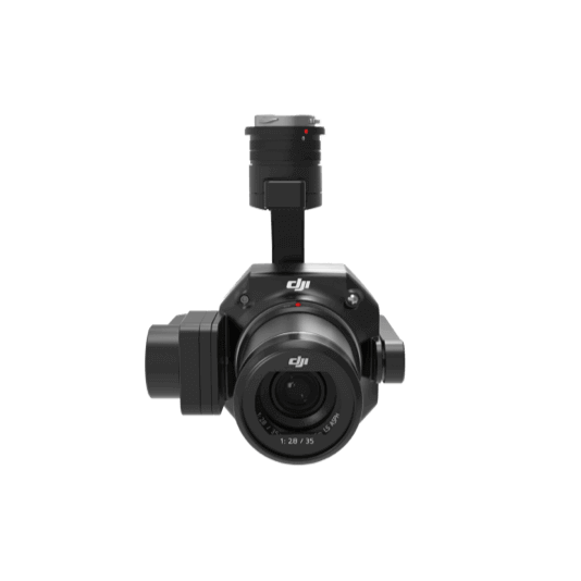
Zenmuse P1
... Open
45 MP Full-frame camera.
Global Mechanical Shutter Shutter Speed 1/2000 Seconds.
3-axis Stabilized Gimbal Smart Oblique Capture.
Global Mechanical Shutter Shutter Speed 1/2000 Seconds.
3-axis Stabilized Gimbal Smart Oblique Capture.

DJI Pilot 2
... Open
Ground control


Workflow
- Mission Planning:
- Plan Mapping Mission based on scene reconstruction needed. - Mission Execution:
- Execute the planned mission. Complement the images with manual flights.
- For night reconstructions, make sure to properly light the scene for accurate data collection. - Post Mission Documentation:
- Import collected data in DJI Terra to process the scene 3D model.
- Use DJI Modify to clean a version of the 3D model, remove any floating parts, and improve overall texture quality. Sharing with other stakeholders is also possible.