Mission Situational Awareness
Gain aerial intel on developing situations with real-time, high-quality imagery, supporting ground teams and enhancing decision-making.
Painpoints
Advantages
Traditional air support, such as helicopters, is limited and costly, leaving ground teams to cover vast areas.
Deploy timely and cost-effective aerial support to assist patrol and tactical teams.
A lack of comprehensive mission information results in exposing ground teams to unnecessary risk.
Eliminate uncertainty with visual and thermal drone data, uncovering hidden dangers and de-escalating situations.
Information is scattered between multiple ground teams and the command center, hindering the response's effectiveness and mission success.
Coordinate teams positions and improve tactical deployment through easy-to-share, live-streamed drone imagery.
Solution
Portable and Fast Aerial Response
Weather Resistant and Quick to Deploy
Outdoor Overwatch Day or Night
Portable and Fast Aerial Response
The Matrice 4T solution offers unparalleled portability for quick reconnaissance missions. Easy to carry on patrol vehicles and equipped with high-resolution visual and thermal sensors, it's an ideal solution for gaining intel on unexpected situations.
Thermal and visual sensors to gather comprehensive aerial intel for your missions.
Compact and lightweight design, around 1.2 kg and easy to carry in the response vehicle.
Fast and easy deployment, get airborne in around 30 seconds.
Superior flight performance with flight time of up to 45 min.
Drone Platform
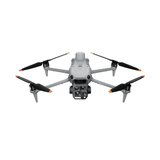
DJI Matrice 4T
... Open
Weight: 1219 g (with propellers)
Max Flight Time (without wind): 49 minutes
Environment Adaptability: Max takeoff altitude 6000 m, max wind speed resistance 12 m/s
Sensing System: Omnidirectional binocular vision system, supplemented with a 3D infrared sensor at the bottom of the aircraft
Wide-Angle Camera: 1/1.3-inch CMOS, 48MP effective pixels (Matrice 4T)
Medium Tele Camera: 1/1.3-inch CMOS, 48MP effective pixels
Telephoto Camera: 1/1.5-inch CMOS, 48MP effective pixels
Infrared Thermal Camera: 1280 × 1024@30fps (Super Resolution enabled, Night Mode not activated)
Laser Rangefinding: 1800m measurement range (1 Hz) @20% reflectivity target
Workflow
- Mission Execution:
- Using DJI Pilot 2 App, add the target location to the map as a GPS Pin.
- Deploy the drone and manually fly towards the area of interest.
- In DJI Pilot 2 Camera View, use AR of the pin to guide the pilot toward the correct location.
- Activate discrete mode for night tactical or sensitive operations.
- Switch between infrared and visual views or use both at the same time to evaluate the situation and provide enhanced situational awareness to ground teams. - Post Mission Documentation:
- Upload the videos and images collected to DJI FlightHub 2 or download from the aircraft SD card for evidence reports or mission debrief.
Weather Resistant and Quick to Deploy
The Matrice 30T, equipped with its hybrid sensor and smart features, provides enhanced situational awareness. Rated with an IP55 Ingress Protection, the M30T is suited to perform under harsh conditions, offering unmatched reliability.
Hybrid payload featuring visual, thermal, and laser range finder sensors provides enhanced mission insights.
Robust and weatherproof airframe graded IP55, allows you to fly when is most needed.
Smart Track and Pin Point features to ease flight operation while keeping targets of interest in frame.
Hot-swappable batteries for continuous operation.
Optical Zoom for mission reconnaissance and target detection from a safe distance.
Drone Platform

Matrice 30T
... Open
Weight (incl. two batteries): 3770 ± 10 g.
Max Flight Time: 41 min.
Sensing system: Six-directional sensing and positioning.
Environment Adaptability: Max Service Ceiling Above Sea Level (without other payload) 7,000 m (with 1676 propellers); Max Wind Resistance 12 m/s.
Zoom camera: 1/2-inch CMOS, Effective pixels: 48MP.
Max Flight Time: 41 min.
Sensing system: Six-directional sensing and positioning.
Environment Adaptability: Max Service Ceiling Above Sea Level (without other payload) 7,000 m (with 1676 propellers); Max Wind Resistance 12 m/s.
Zoom camera: 1/2-inch CMOS, Effective pixels: 48MP.
Workflow
- Mission Execution:
- Using DJI Pilot 2 App, add the target location to the map as a GPS Pin.
- Deploy the drone and manually fly towards the area of interest.
- In DJI Pilot 2 Camera View, use AR of the pin to guide the pilot toward the correct coordinates.
- Activate discrete mode for night or sensitive operations.
- Switch between infrared and visual views to evaluate the situation and provide enhanced situational awareness to ground teams.
- Use the Smart Track function to keep track of moving objects while reducing pilot cognitive load.
- Pin locations of interest and easily center the camera on them. - Post Mission Documentation:
- Upload the videos and images collected to DJI FlightHub 2 or download from the aircraft SD card for evidence reports or mission debrief.
Outdoor Overwatch Day or Night
The Matrice 400 sets the standard for high-performance, multipurpose drone solutions. Equipped with the Zenmuse H30T multi-sensor payload, which includes zoom, wide, and thermal cameras, it provides optimal performance for law enforcement overwatch operations, day or night.
Robust and weatherproof airframe graded IP55, allows you to fly when is most needed.
Night Scene Mode and NIR Auxiliary Light features for night operations.
Optimal operational efficiency with extended flight time of up to 59 min.
Laser detection range up to 3,000 meters to get the accurate location of points of interest.
Drone Platform
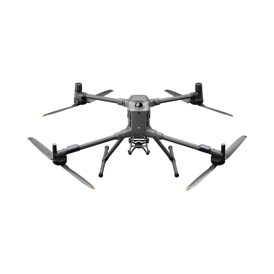
DJI Matrice 400
... Open
Weight: 9740±40 g (with batteries)
Max Takeoff Weight: 15.8 kg
Max Payload: 6 kg
Max Flight Time: 59 minutes
Max Horizontal Speed: 25 m/s
Sensing System: Omnidirectional binocular vision system (surround view provided by full-color fisheye vision sensors), horizontal rotating LiDAR, upper LiDAR, downward 3D infrared range sensor, and six-direction mmWave radar
Environment Adaptability: IP55 rating, max takeoff altitude 7000 m, operating temperature -20° to 50° C (-4° to 122° F)
Compatible with the Zenmuse H30 Series, Zenmuse L2, Zenmuse P1, Zenmuse V1, Zenmuse S1, and third-party payloads.
Payload And Software
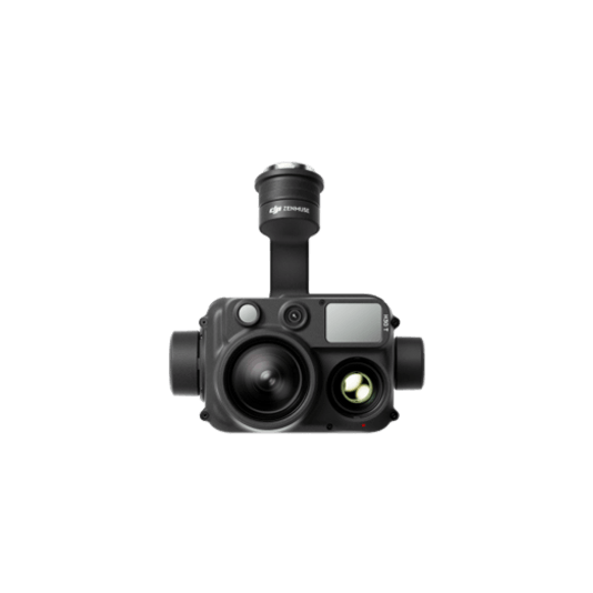
Zenmuse H30T
... Open
Wide-Angle RGB Camera: 1/1.3-inch CMOS, 48MP effective pixels
Zoom RGB Camera: 1/1.8-inch CMOS, 40MP effective pixels, 34× hybrid optical zoom
Infrared Thermal Camera: 1280×1024@30fps
NIR Auxiliary Light Illumination Range: Approx. 8m diameter circle@100 m
Laser Range Finder: Max measurement range 3000 m
Zoom RGB Camera: 1/1.8-inch CMOS, 40MP effective pixels, 34× hybrid optical zoom
Infrared Thermal Camera: 1280×1024@30fps
NIR Auxiliary Light Illumination Range: Approx. 8m diameter circle@100 m
Laser Range Finder: Max measurement range 3000 m


DJI Pilot 2
... Open
Ground control
Workflow
- Mission Execution:
- Using DJI Pilot 2 App, add the target location to the map as a GPS Pin.
- Deploy the drone and manually fly towards the area of interest.
- In DJI Pilot 2 Camera View, use AR of the pin to guide the pilot toward the correct coordinates.
- Activate discrete mode for night or sensitive operations.
- Switch between infrared and visual views to evaluate the situation and provide enhanced situational awareness to ground teams.
- Use the Smart Track function to keep track of moving objects while reducing pilot cognitive load.
- Pin locations of interest and easily center the camera on them. - Post Mission Documentation:
- Upload the videos and images collected to DJI FlightHub 2 or download from the aircraft SD card for evidence reports or mission debrief.