Private Security
Swiftly patrol large areas to identify potential security threats and support ground teams with enhanced situational awareness.
Painpoints
Advantages
Fixed security systems may offer limited coverage and can be vulnerable to blind spots, potentially compromising their effectiveness.
Gain full insights into the status of the perimeter and patrol areas with bird's-eye visual and thermal views.
In the event of a triggered alarm or security breach, security teams need to mobilize to the location to assess the situation, which may reduce overall effectiveness.
Rapidly assess the situation's status, gauge the severity, and deploy security teams more effectively.
Intruders might be prepared for the response actions and tactics, exposing security personnel to unexpected dangerous situations.
Support security response with aerial intel to reduce personnel risk and enhance decision-making with real-time data.
Solution
Automated Patrol
Versatile Thermal
Portable Patrol and Response
Automated Patrol
The DJI Dock 3 enables private security teams to continuously perform scheduled and on-demand aerial patrols. Equipped with visual and thermal sensors, the Matrice 4TD offers superior performance in detecting potential risks not captured by fixed security systems. Integrate external alarm systems through the DJI FlightHub 2 API for an automated aerial security solution.
Thermal and visual sensors to gather comprehensive aerial intel for your missions.
FlyTo missions to optimize flight response.
Manual controls for developing situations that require human intervention.
Reduced operational risk with the Task Area Management feature.
Drone Platform
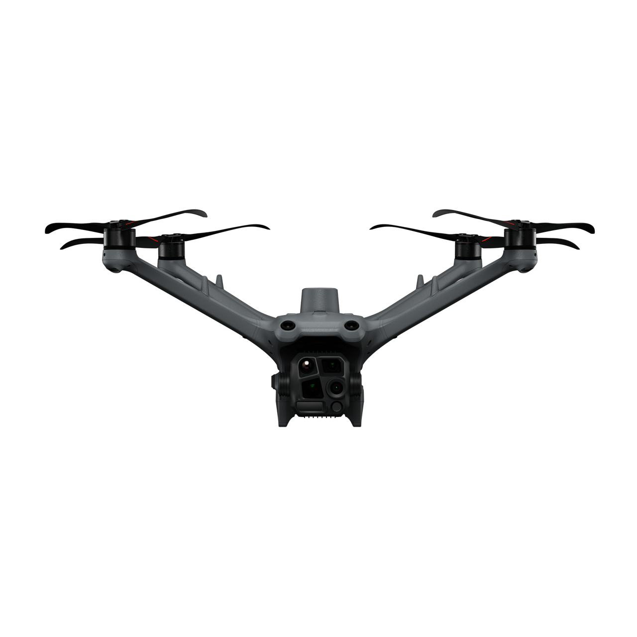
DJI Matrice 4TD
... Open
Weight: 1850 g
Max Flight Time: 54 minutes
Environment Adaptability: IP55 rating, max takeoff altitude 6500 m, max wind speed resistance 12 m/s
Sensing System: Omnidirectional binocular vision system, supplemented with a 3D infrared sensor at the bottom of the aircraft
Wide-Angle Camera: 1/1.3-inch CMOS, 48MP effective pixels
Medium Tele Camera: 1/1.3-inch CMOS, 48MP effective pixels
Telephoto Camera: 1/1.5-inch CMOS, 48MP effective pixels
Infrared Thermal Camera: 1280 × 1024@30fps (UHR Infrared Image function enabled, Night Scene mode not enabled)
Laser Rangefinding: 1800m measurement range (1 Hz) @20% reflectivity target
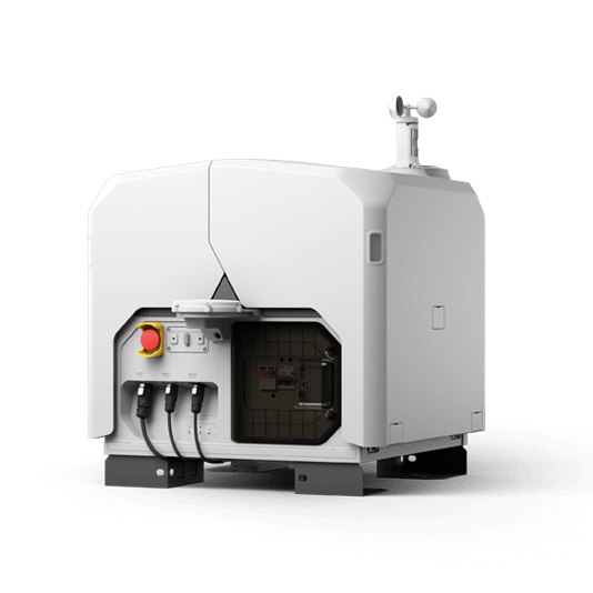
DJI Dock 3
... Open
Weight: 55 kg (without the drone)
Size: 1760×745×485 mm (L×W×H, dock cover opened)
Environment Adaptability: -30° to 50° C (-22° to 122° F) operating temperature, IP56 rating, maximum operating altitude 4500 m
Max Operating Radius: 10 km
Charging Time: 27 minutes
Security Camera (Internal) Resolution: 1920×1080
Size: 1760×745×485 mm (L×W×H, dock cover opened)
Environment Adaptability: -30° to 50° C (-22° to 122° F) operating temperature, IP56 rating, maximum operating altitude 4500 m
Max Operating Radius: 10 km
Charging Time: 27 minutes
Security Camera (Internal) Resolution: 1920×1080
Payload And Software

Workflow
- Mission Planning:
(1) For Patrol Missions:
- Using the waypoint mission planning feature in DJI FlightHub 2, determine the perimeter to be inspected, making sure to cover potential blind spots or frequently breached points.
(2) For Alarm Response:
- Using the DJI FlightHub 2 platform, take control of the DJI Dock 3 closest to the alarm location and launch the drone. Search for the coordinates on the map and set it as Fly-to destination. - Mission Execution:
- The drone automatically takes off and starts the flight mission.
- The pilot can take over live flight control and operate the drone, payload, and switch between the Wide, Tele, and IR cameras as needed.
- Live stream the drone images to command centers through DJI FlightHub 2. - Post Mission Documentation:
- Captured videos and photos will automatically be uploaded to DJI FlightHub 2 to be used as evidence or debrief documentation.
Versatile Thermal
The Matrice 30T strikes the perfect balance between portability and performance. It integrates a hybrid sensor with visual, thermal, and laser range finder capabilities into a mid-size, weather and dust-proof airframe for optimal operation in challenging environments.
Rugged, weatherproof mid-size airframe, provides balance between portability and endurance.
640 × 512 thermal radiometric sensor for accurate temperature readings.
Get coordinates of critical points through the laser range finder sensor.
Dual camera views for comprehensive situational awareness.
Enhanced optical zoom for detailed target observation.
Drone Platform

Matrice 30T
... Open
Weight (incl. two batteries): 3770 ± 10 g.
Max Flight Time: 41 min.
Sensing system: Six-directional sensing and positioning.
Environment Adaptability: Max Service Ceiling Above Sea Level (without other payload) 7,000 m (with 1676 propellers); Max Wind Resistance 12 m/s.
Zoom camera: 1/2-inch CMOS, Effective pixels: 48MP.
Max Flight Time: 41 min.
Sensing system: Six-directional sensing and positioning.
Environment Adaptability: Max Service Ceiling Above Sea Level (without other payload) 7,000 m (with 1676 propellers); Max Wind Resistance 12 m/s.
Zoom camera: 1/2-inch CMOS, Effective pixels: 48MP.

Workflow
- Mission Execution:
- Using DJI Pilot 2 App, add the alarm location to the map as a GPS Pin.
- In DJI Pilot 2 camera view, use AR of the pin to guide the pilot toward the correct coordinates.
- Fly manually over the incident area switching between visual and thermal views for enhanced situational awareness.
- Use the Smart Track feature to take cognitive load off the pilots and keep target moving objects centered.
- Live stream the drone images to command centers through DJI FlightHub 2. - Post Mission Documentation:
- Captured videos and photos can be uploaded to DJI FlightHub 2 or downloaded from the SD card to be used as evidence or debrief documentation.
Portable Patrol and Response
The Matrice 4T offers unparalleled portability and performance for private security teams. Easy to carry and equipped with visual and thermal cameras, it provides a quick assessment in the event of a security breach. Livestream the aerial feed to command centers through DJI FlightHub 2 for enhanced cross-team collaboration.
Compact and lightweight design, around 1.2kg and easy to carry in the patrol vehicle.
640 × 512 thermal radiometric sensor for accurate temperature readings.
Thermal palettes and temperature measurement tools for easy data interpretation.
Fast and easy deployment, get airborne in around 30 seconds.
Drone Platform
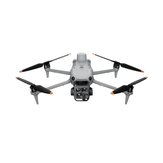
DJI Matrice 4T
... Open
Weight: 1219 g (with propellers)
Max Flight Time (without wind): 49 minutes
Environment Adaptability: Max takeoff altitude 6000 m, max wind speed resistance 12 m/s
Sensing System: Omnidirectional binocular vision system, supplemented with a 3D infrared sensor at the bottom of the aircraft
Wide-Angle Camera: 1/1.3-inch CMOS, 48MP effective pixels (Matrice 4T)
Medium Tele Camera: 1/1.3-inch CMOS, 48MP effective pixels
Telephoto Camera: 1/1.5-inch CMOS, 48MP effective pixels
Infrared Thermal Camera: 1280 × 1024@30fps (Super Resolution enabled, Night Mode not activated)
Laser Rangefinding: 1800m measurement range (1 Hz) @20% reflectivity target
Workflow
- Mission Execution:
(1) For Alarm Response:
- Using DJI Pilot 2 App, add the last known location to the map as a GPS Pin.
- Fly manually over to the incident area switching between visual and thermal views for enhanced situational awareness.
(2) For Patrol Missions:
- Plan perimeter mission using DJI Pilot 2 or DJI FlightHub 2 waypoint mission planning feature.
- Select the flight plan and execute the mission.
- Stop and resume the mission depending on the needs.
- Live stream the drone images to command centers through DJI FlightHub 2. - Post Mission Documentation:
- Captured videos and photos can be uploaded to DJI FlightHub 2 or downloaded from the SD card to be used as evidence or debrief documentation.