Search and Rescue
Swiftly aid search and rescue missions by covering extensive and difficult-to-navigate landscapes, utilizing aerial thermal imaging to pinpoint the whereabouts of lost individuals.
Painpoints
Advantages
Rescue missions often occur on vast and challenging terrains, which can limit ground search capabilities.
Cover large areas more efficiently with drone-based search missions.
Lack of accurate coordinates and visual references can negatively impact response missions.
Provide accurate coordinates and visual references to ground teams for more efficient rescue missions.
Certain terrains and conditions pose challenges to easily identifying a missing person through visual ground searches.
Overcome terrain and visibility challenges with aerial searches that detect heat patterns.
Solution
Portable Thermal
Versatile Thermal
Robust Multi-Purposed Search
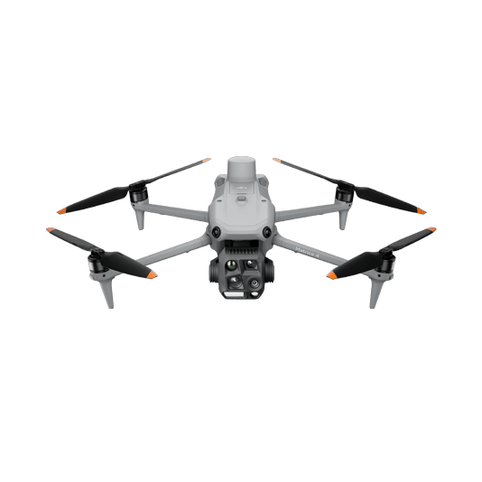
Portable Thermal
The Matrice 4T offers unparalleled portability and thermal capabilities for rescue teams. Easy to carry and equipped with visual and thermal cameras, it provides quick aerial support when time matters the most. Livestream the aerial feed to command centers through DJI FlightHub 2 for enhanced cross-team collaboration.
Compact and lightweight design, around 1.2kg and easy to carry in the response vehicle.
Fast and easy deployment, get airborne in around 30 seconds.
640 × 512 thermal radiometric sensor for accurate temperature readings.
Thermal palettes and temperature measurement tools for easy data interpretation.
Drone Platform
DJI Matrice 4T
... Open
Weight: 1219 g (with propellers)
Max Flight Time (without wind): 49 minutes
Environment Adaptability: Max takeoff altitude 6000 m, max wind speed resistance 12 m/s
Sensing System: Omnidirectional binocular vision system, supplemented with a 3D infrared sensor at the bottom of the aircraft
Wide-Angle Camera: 1/1.3-inch CMOS, 48MP effective pixels (Matrice 4T)
Medium Tele Camera: 1/1.3-inch CMOS, 48MP effective pixels
Telephoto Camera: 1/1.5-inch CMOS, 48MP effective pixels
Infrared Thermal Camera: 1280 × 1024@30fps (Super Resolution enabled, Night Mode not activated)
Laser Rangefinding: 1800m measurement range (1 Hz) @20% reflectivity target
Workflow
- Mission Execution:
- Fly manually over the last known location following a search pattern such as the spiral route.
- Draw points, lines, or polygons on a map on DJI FlightHub 2 to mirror the last known location, trails, or key areas of interest.
- Select a suitable infrared palette and gain mode for the conditions at hand. White Hot and Black Hot palettes are preferred.
- Switch between infrared and visual cameras. Use the Link Zoom feature to zoom in simultaneously with thermal and visual sensors.
- As the situation allows, generate a rapid 2D map on DJI FlightHub 2 to provide a better understanding of search area and routes.
- Once the subject is identified, mark the location with the drone flying over.
- Communicate with the rescuee and rescue teams using the speaker if applicable.
- Support team on the rescue mission providing lighting from the drone using the spotlight.
Versatile Thermal
The Matrice 30T strikes the perfect balance between portability and performance. It integrates a hybrid sensor with visual, thermal, and laser range finder capabilities into a mid-size, weather and dust-proof airframe for optimal operation in challenging environments.
Rugged, weatherproof mid-size airframe, provides balance between portability and endurance.
640 × 512 thermal radiometric sensor for accurate temperature readings.
Get coordinates of critical points through the laser range finder sensor.
Dual camera views for comprehensive situational awareness.
Drone Platform

Matrice 30T
... Open
Weight (incl. two batteries): 3770 ± 10 g.
Max Flight Time: 41 min.
Sensing system: Six-directional sensing and positioning.
Environment Adaptability: Max Service Ceiling Above Sea Level (without other payload) 7,000 m (with 1676 propellers); Max Wind Resistance 12 m/s.
Zoom camera: 1/2-inch CMOS, Effective pixels: 48MP.
Max Flight Time: 41 min.
Sensing system: Six-directional sensing and positioning.
Environment Adaptability: Max Service Ceiling Above Sea Level (without other payload) 7,000 m (with 1676 propellers); Max Wind Resistance 12 m/s.
Zoom camera: 1/2-inch CMOS, Effective pixels: 48MP.
Workflow
- Mission Execution:
- Fly manually over the last known location following a search pattern such as the spiral route.
- Draw points, lines, or polygons on a map on DJI FlightHub 2 to mirror the last known location, trails, or key areas of interest.
- Select a suitable infrared palette and gain mode for the conditions at hand. White Hot and Black Hot palettes are preferred.
- Switch between infrared and visual cameras. Use the Link Zoom feature to zoom in simultaneously with thermal and visual sensors.
- For night missions, operators can choose to disable the IR Cut Filter of the zoom camera for enhanced night visibility.
- As the situation allows, generate a rapid 2D map on DJI FlightHub 2 to provide a better understanding of search area and routes.
- Once the subject is identified. Get the coordinates of subject using the laser range finder and the Pin Point function or draw out routes and areas to avoid.
- Share Pin Point coordinates to ground teams through DJI Pilot 2 QR code or DJI FlightHub 2.
- Communicate with the rescuee and rescue teams using the speaker if applicable.
- Support team on the rescue mission providing lighting from the drone using the spotlight.
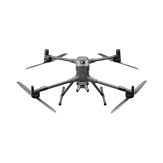
Robust Multi-Purposed Search
The Matrice 400, equipped with the Zenmuse H30T, brings enhanced thermal capabilities to search and rescue teams. Add a spotlight and speakers to aid the ground team during rescue missions.
Reliable multipurpose drone platform easily adapts to the mission needs.
Powerful Infrared Sensor with 1280 × 1024 resolution provides superb thermal imagery.
Robust and reliable, IP54 graded, allows you to fly when is most needed.
Laser range finder to get accurate coordinates of objects up to 3,000 meters of range.
Additional more powerful payload capabilities such as spotlight, speakers or drop systems to assist on the rescue mission.
Drone Platform
DJI Matrice 400
... Open
Weight: 9740±40 g (with batteries)
Max Takeoff Weight: 15.8 kg
Max Payload: 6 kg
Max Flight Time: 59 minutes
Max Horizontal Speed: 25 m/s
Sensing System: Omnidirectional binocular vision system (surround view provided by full-color fisheye vision sensors), horizontal rotating LiDAR, upper LiDAR, downward 3D infrared range sensor, and six-direction mmWave radar
Environment Adaptability: IP55 rating, max takeoff altitude 7000 m, operating temperature -20° to 50° C (-4° to 122° F)
Compatible with the Zenmuse H30 Series, Zenmuse L2, Zenmuse P1, Zenmuse V1, Zenmuse S1, and third-party payloads.
Payload And Software
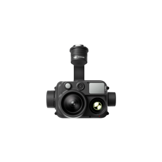
Zenmuse H30T
... Open
Wide-Angle RGB Camera: 1/1.3-inch CMOS, 48MP effective pixels
Zoom RGB Camera: 1/1.8-inch CMOS, 40MP effective pixels, 34× hybrid optical zoom
Infrared Thermal Camera: 1280×1024@30fps
NIR Auxiliary Light Illumination Range: Approx. 8m diameter circle@100 m
Laser Range Finder: Max measurement range 3000 m
Zoom RGB Camera: 1/1.8-inch CMOS, 40MP effective pixels, 34× hybrid optical zoom
Infrared Thermal Camera: 1280×1024@30fps
NIR Auxiliary Light Illumination Range: Approx. 8m diameter circle@100 m
Laser Range Finder: Max measurement range 3000 m

DJI Pilot 2
... Open
Ground control

Workflow
- Mission Execution:
- Fly manually over the last known location following a search pattern such as the spiral route.
- Draw points, lines, or polygons on a map on DJI FlightHub 2 to mirror the last known location, trails, or key areas of interest.
- Select a suitable infrared palette and gain mode for the conditions at hand. White Hot and Black Hot palettes are preferred.
- Switch between infrared and visual cameras. Use the Link Zoom feature to zoom in simultaneously with thermal and visual sensors.
- For night missions, operators can choose to disable the IR Cut filter and enabling the IR spotlight of the zoom camera for enhanced night visibility.
- As the situation allows, generate a rapid 2D map on DJI FlightHub 2 to provide a better understanding of search area and routes.
- Once the subject is identified. Get the coordinates of subject using the laser range finder and the Pin Point function or draw out routes and areas to avoid.
- Share Pin Point coordinates to ground teams through DJI Pilot 2 QR code or DJI FlightHub 2.
- Communicate with the rescuee and rescue teams using the speaker if applicable.
- Support team on the rescue mission providing lighting from the drone using the spotlight.