Wildfires
Enhance wildfire response by providing critical aerial information. Identify hotspots more accurately and improve responders' safety while aiding in the strategic deployment of resources.
Painpoints
Advantages
The rapid expansion and unpredictability of wildfires complicate ground crews' ability to evaluate the situation in real time and make accurate decisions.
Gain real-time aerial insights, enabling firefighters to make informed, strategic decisions amidst the chaos of wildfires.
Firefighters face significant risks due to their limited knowledge of the situation.
Enhance personnel safety with advanced situational awareness, thereby reducing firefighters' exposure to hidden dangers.
A lack of information makes it difficult for incident commanders to effectively deploy resources and track the effectiveness of mitigation efforts.
Collect critical data to optimize resource allocation and monitor the impact of firefighting strategies in real time.
Solution
Portable and Rapid Response
High Performance Fire Response
Versatile Aerial Thermal Reconnaissance
Portable and Rapid Response
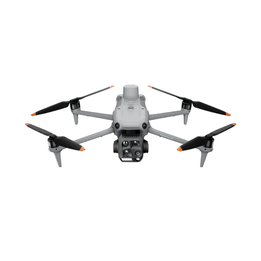
The Matrice 4T offers unparalleled portability for quick deployment missions. Easy to carry on fire response vehicles and equipped with visual and thermal cameras, it's the ideal solution for initial risk evaluations.
Compact and lightweight design, around 1.2 kg and easy to carry in the response vehicle.
Fast and easy deployment, get airborne in around 30 seconds.
640 × 512 thermal radiometric sensor for accurate temperature readings.
Thermal palettes and temperature measurement tools for easy data interpretation.
Drone Platform
DJI Matrice 4T
... Open
Weight: 1219 g (with propellers)
Max Flight Time (without wind): 49 minutes
Environment Adaptability: Max takeoff altitude 6000 m, max wind speed resistance 12 m/s
Sensing System: Omnidirectional binocular vision system, supplemented with a 3D infrared sensor at the bottom of the aircraft
Wide-Angle Camera: 1/1.3-inch CMOS, 48MP effective pixels (Matrice 4T)
Medium Tele Camera: 1/1.3-inch CMOS, 48MP effective pixels
Telephoto Camera: 1/1.5-inch CMOS, 48MP effective pixels
Infrared Thermal Camera: 1280 × 1024@30fps (Super Resolution enabled, Night Mode not activated)
Laser Rangefinding: 1800m measurement range (1 Hz) @20% reflectivity target

Workflow
- Mission Execution:
- Fly manually over the affected area looking for hotspots. Switch between infrared and visual views to evaluate the situation.
- Use the Link Zoom feature to zoom in simultaneously with thermal and visual sensor.
- Select a suitable infrared palette and gain mode for the conditions at hand.
- Use orbit flights to perform 360 circular flights around the structure, facilitating the risk evaluation. - Post Mission Documentation:
- Map the affected areas for post-incident reports and reforestation efforts.
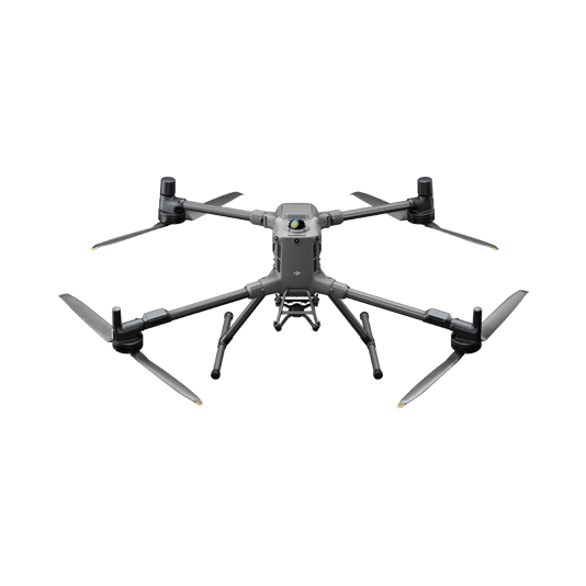
High Performance Fire Response
The Matrice 400, equipped with the Zenmuse H30T, brings enhanced thermal capabilities to fire response. Using the new H30T Night Scene mode, fire brigades can now gain valuable insights during low-light operations.
Reliable multipurpose drone platform easily adapts to the mission needs.
Powerful infrared sensor with 1280 × 1024 resolution provides superb thermal imagery.
Robust and reliable, IP54 graded, allows you to fly when is most needed.
Laser range finder to get accurate coordinates of objects up to 3,000 meters.
Enhanced full-color or black-white night vision to easily identify risks.
Drone Platform
DJI Matrice 400
... Open
Weight: 9740±40 g (with batteries)
Max Takeoff Weight: 15.8 kg
Max Payload: 6 kg
Max Flight Time: 59 minutes
Max Horizontal Speed: 25 m/s
Sensing System: Omnidirectional binocular vision system (surround view provided by full-color fisheye vision sensors), horizontal rotating LiDAR, upper LiDAR, downward 3D infrared range sensor, and six-direction mmWave radar
Environment Adaptability: IP55 rating, max takeoff altitude 7000 m, operating temperature -20° to 50° C (-4° to 122° F)
Compatible with the Zenmuse H30 Series, Zenmuse L2, Zenmuse P1, Zenmuse V1, Zenmuse S1, and third-party payloads.
Payload And Software
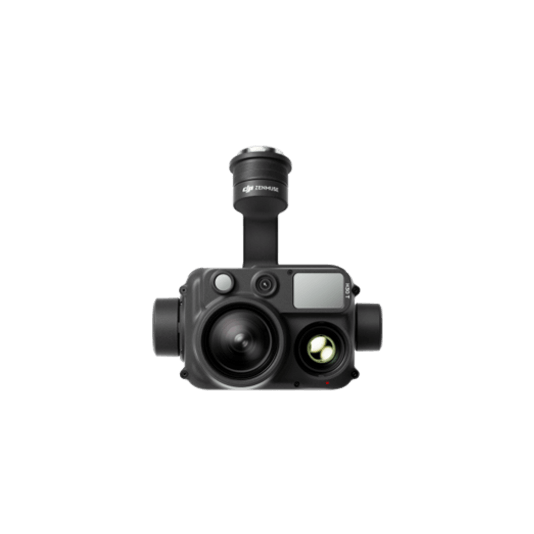
Zenmuse H30T
... Open
Wide-Angle RGB Camera: 1/1.3-inch CMOS, 48MP effective pixels
Zoom RGB Camera: 1/1.8-inch CMOS, 40MP effective pixels, 34× hybrid optical zoom
Infrared Thermal Camera: 1280×1024@30fps
NIR Auxiliary Light Illumination Range: Approx. 8m diameter circle@100 m
Laser Range Finder: Max measurement range 3000 m
Zoom RGB Camera: 1/1.8-inch CMOS, 40MP effective pixels, 34× hybrid optical zoom
Infrared Thermal Camera: 1280×1024@30fps
NIR Auxiliary Light Illumination Range: Approx. 8m diameter circle@100 m
Laser Range Finder: Max measurement range 3000 m

DJI Pilot 2
... Open
Ground control

Workflow
- Mission Execution:
- Fly manually over the affected area looking for hotspots. Switch between infrared and visual views to evaluate the situation.
- Use the Link Zoom feature to zoom in simultaneously with thermal and visual sensors.
- Select a suitable infrared palette and gain mode for the conditions at hand.
- Install the IR Density Filter to increase the measurement range of the thermal sensor.
- Get the coordinates of hotspots using the laser range finder and the Pin Point function.
- Share the coordinates with ground teams through the DJI Pilot 2 QR code or DJI FlightHub 2. - Post Mission Documentation:
- Collect the videos and photos captured during the mission through DJI FlightHub 2 or download from the payload SD card to be used as supporting documentation for post-disaster analysis.
Versatile Aerial Thermal Reconnaissance
The Matrice 30T strikes the perfect balance between portability and performance. It integrates a hybrid sensor with visual, thermal, and laser range finder capabilities, ensuring optimal performance across a variety of fire emergencies.
Rugged, weatherproof mid-size airframe, provides balance between portability and endurance.
640 × 512 thermal radiometric sensor for accurate temperature readings.
Optical zoom for detailed object inspection from a safe distance.
Laser range finder to get accurate coordinates of targets.
Hot-swappable batteries and improved charging station for continuous operation.
Night scene feature provides enhanced awareness for low-light operations.
Drone Platform

Matrice 30T
... Open
Weight (incl. two batteries): 3770 ± 10 g.
Max Flight Time: 41 min.
Sensing system: Six-directional sensing and positioning.
Environment Adaptability: Max Service Ceiling Above Sea Level (without other payload) 7,000 m (with 1676 propellers); Max Wind Resistance 12 m/s.
Zoom camera: 1/2-inch CMOS, Effective pixels: 48MP.
Max Flight Time: 41 min.
Sensing system: Six-directional sensing and positioning.
Environment Adaptability: Max Service Ceiling Above Sea Level (without other payload) 7,000 m (with 1676 propellers); Max Wind Resistance 12 m/s.
Zoom camera: 1/2-inch CMOS, Effective pixels: 48MP.
Workflow
- Mission Execution:
- Fly manually over the affected area looking for hotspots. Switch between infrared and visual views to evaluate the situation.
- Use the Link Zoom feature to zoom in simultaneously with thermal and visual sensor.
- Select a proper infrared palette and gain mode for the conditions at hand.
- Get the coordinates of hotspots using the laser range finder and the Pin Point function.
- Share the coordinates with ground teams through the DJI Pilot 2 QR code or DJI FlightHub 2.
- Use orbit flights to perform 360 circular flights around the structure, facilitating the risk evaluation. - Post Mission Documentation:
- Collect the videos and photos captured during the mission through DJI FlightHub 2 to be used as supporting documentation for post-disaster analysis.